Reorganization meeting reaches out to 15 local towns that saw armies in action in 1777 battle
By Mike McGann, Editor, KennettTimes.com

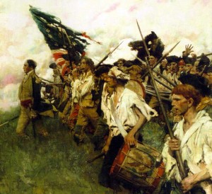
"Nation Makers" by Howard Pyle, the legendary local artist, part of the collection at the Brandywine River Museum. This is Pyle's imagined vision of Gen. George Washington leading troops in battle — some say at Brandywine, although in reality, Washington commanded the battle from a headquarters in Chads Ford.
CHADDS FORD — You may not think you live in a historic battlefield site, but residents of a number of local towns might be surprised to find that they are now considered to be part of the Brandywine Battlefield — at least according to new federal standards.
Because of this, the Brandywine Battlefield Task Force invited officials from 15 local municipalities to an organizing meeting, in an effort to jump start local preservation efforts — and keep the Chadds Ford battlefield park operating.
Because new standards to define a battlefield now include not just where shots were fired, but rather troop movement and pre- and post-battle encampment, a lot more local municipalities are now considered to have been part of the engagement. 15, up from the original six, including Chadds Ford, Pennsbury and Birmingham (where much of the fighting happened).
But now New Garden, Kennett Township, Kennett Square, East Marlborough, Pocopson and Newlin are now considered fully part of the battle. British troops camped and began their march in the early hours of Sept. 11, 1777, to either the banks of the Brandywine in Pennsbury, or, as proved pivotal, a force under General Charles Cornwallis marched north through East Marlborough, Pocopson and Newlin seeking an unguarded ford over the Brandywine to outflank Gen. George Washington’s forces. The flanking movement worked, and the Continentals were routed, saved only by a brave rear guard action in Concord that saved the main body of the American army to fight another day. The defeat did lead to capture of Philadelphia by the British.
While preservation efforts — mostly in the form of development easements — have been focused on Chadds Ford, where the park is, and Birmingham, where most of the actual fighting took place, the task force is looking at a wider world, now.
“We invited you here, to get you re-involved,” said Jeannine Speirs, who serves as chair of the task force, and is a senior community planner for the Chester County Planning Commission, speaking to local representatives of 15 invited local municipalities.
The park — and efforts to preserve the surrounding battlefield area — have been in flux since 2009 when the Pennsylvania Historic and Museum Commission (PHMC) stopped funding the daily operation of the park. Since then, local volunteers and some local governments have been working to keep the park open, albeit in a limited fashion.
Currently, the task force has been driven by Chester and Delaware counties, PHMC (which still funds maintenance at the site), the Brandywine Conservancy, which has led the efforts to acquire easements for much the 2,700 acres of land that has been preserved to date, the Chadds Ford Historical Society and the Friends of Brandywine Battlefield. Speirs said she and rest of the task force wants to re-engage local municipalities, as well as PennDOT and the National Park Service.
The idea would be to have the bigger group meet twice a year, with a smaller steering committee — primarily the group engaged regularly now — meeting monthly to manage day-to-day operations.
As another part of Wednesday’s presentation, Sean Moir of Chester County’s Geographic Information Systems section of the county’s Department of Computer and Information Services showed off an interactive, real-time map of the battle’s events. Moir will be giving a more detailed presentation on June 19 at the Exton Libary.
David Shields, the Associate Director of the Land Stewardship Program from the Brandywine Conservancy, walked the group through the efforts over the last decade to purchase easements — and in at least once case, purchase the property — to make sure that battlefield lands don’t end up as housing developments.
The group is expected to meet again in the fall.


